| The party begins in the Town (south west) and decide to hire a rowboat to explore the lake to investigate reports of patches of churning water. |

|
|
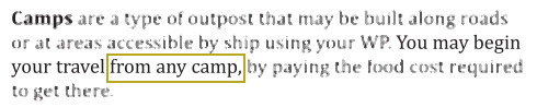
The adventurers could begin their expedition from any Outpost such as a camp. However, the Town hires out rowboats, so they choose to begin there. |
| Half-way between two Landmarks (the island to the west and the headland to the east) they encounter their mission objective Location. |

|

|
The party has not been to the island, nor to the
headland. Therefore, these two Locations
only qualify as being Landmarks because
the party hasn't actually been there. In contrast, the party has been to the pool of churning waters, however because it is not visually distinctive at range, it cannot be a Landmark, and that prevents it qualifying for being added to a map unless you make the map right there which takes an hour to do. |
| A tree-trunk falls from the sky and sinks the boat. The party swim to shore. Since they have found what they were looking for, they take a brief break and during it, they make a map to assist locating the water patch again in the future. |

|
|
Even though the pool in the lake is your
Final Location, you cannot create a map
while swimming so you can only create the map
once you reach the shore. Having reached the
shore, you must create the map to
where you are which likely isn't a spot you
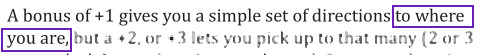
actually care about getting to in the future. At this point, you can optionally include any number of Landmarks (such as "the island" and "the headland") and they automatically become Final Locations. However, they are also likely to be spots you don't actually care about getting to in the future. The only place you want to return to in the future is the pool of churning water, but you cannot include it in your map unless that is where you are at the instant you make your map. |
| Since they no longer have a boat, they must now walk back towards civilisation. The closest Outpost is a Camp (south east). |

|
|
While travelling from the Location to the Town, the party may encounter (for example) a shrine or some ruins on the path taken for the return journey. Each such encounter counts as an Extra Location. The map already created has capacity to accept a small number of retrofitted Extra Locations. |
| From there, they may optionally travel by road back to the Town (since that is where write-ups are submitted). |

|

|
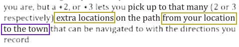
If you have a Map Bonus providing you with a
capacity of Extra Locations, they
must be on the route to Town,
not any other Outpost. By default, expeditions terminate at the Town (although any Outpost is otherwise permissible, such as a camp or a ship). |
| The party can now submit to Omet a map which details how to get from the Final Location to a shrine and some ruins on the way back to Town, but crucially this map does not tell anyone how to find the pool of churning waters which was the entire point in the first place. |

|


|
Pay 10 gold pieces to Omet, and
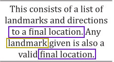
they will take your Map from you. Each Map is a
mixture of both Locations (since Landmarks
count as Final Locations) and Destinations. Subsequent adventurers can revisit a Location or Destination which previous adventurers have catalogued. Omet will also take Directions from you at a cost (to you) proportional to how many Destinations your Directions list. Typically, you will list several Landmarks (to aid orientation); a Final Location (where you crafted the map — ideally your objective); and a number of Extra Locations (on your way back from the Location to the Town). But the number of Destinations is always going to be one: the Outpost you finish at. |